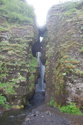
Our first stop was to the impressive Skogafoss waterfall, which stands about 60 meters tall and is about 25 meters wide. The waterfall has a lot of power to it and you can hear the thundering of the bottom of it from afar. We were pretty surprised that we were able to get so close to the base of it given how forceful it is. We walked up to about as far as we could get without getting soaking wet. After all, we did have a lot to do that day!
Stairs and a path next to the waterfall led us all the way to the top (as well as testing our fitness) to some precarious views down below. These stairs also mark the start of one of the most popular hiking trails in Iceland, taking you 55 kilometers to Landmannalaugaur.
Next we drove about 20 minutes to Sólheimajökull glacier. This glacier snout is part of the much bigger Mýrdalsjökull glacier. They say that Sólheimajökull is shrinking and retreating, and has retreated about a kilometer in the last decade. As you walk towards the glacier you can even see where it used to be since it is either covered by water or rough stony ground.
 |
| Do you think it's cold? |

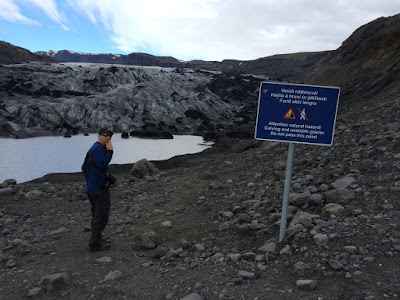 |
| Don't pass the sign! |
I've got to admit, it was pretty cool looking at a glacier that has probably been there since the Ice Age. Next time I think we'll sign up for a glacial walk so we can really see all of the different formations, ice ridges, and small glacial streams.
Our next stop is a really interesting and random find. On November 24, 1973, a U.S. Navy plane was forced to land on the black sand beach of Solheimasandur in Southern Iceland. The crew survived, but the plane was abandoned, rather than recovered, and it rests there still. Extreme weather (and looters?) has taken its toll on the plane, but the shell and half of both wings still remain.
The plane was somewhat of a challenge to get to. This site isn't in your Lonely Planet or Rick Steves' books - we just happened to find it on a blog a few days before we arrived in Iceland and it gave very detailed instructions on how to find it. There are no signs from the main road and when you do come to the subtle turn off the road, there is a teeny tiny sign pointing that the site is about 5 km away. The "road" to the site (packed gravel and rocks) is bumpy and full of potholes! Rocks were kicking up into the tires and metal and I was afraid that we were going to puncture something as we drove very slowly towards the south. It took a good 15-20 minutes to get down towards the water, but when we came around a small corner you couldn't miss this incredible site.
 |
| The tiny sign that's only noticeable after you make the turn |
Our last stop of the day took us to Reynisfjara Beach, about five minutes from the tiny town of Vik where we were staying for the next two nights. Reynisfjara Beach was voted as one of the most ten beautiful non-tropical beaches on Earth... and it was easy to see why! There's a lot to see at this fascinating and eerie beach. In the distance off-shore you can see the Reynisdrangar rock formations, which look like spooky spindles of rock sticking out of the ocean. Legend has it that three trolls were pulling a three masted ship to shore, but were caught at dawn by the sunlight and were turned into rocks. I'm not exactly sure where these photos are... I hope we took some! The pictures below are views of Dyrhólaey, which has a naturally formed arch that serves as a large bird refuge.
On the beach there are stunning basalt columns. They were created when magma cooled slowly and then cracked into columns as the surface area decreased. These were just spectacular to look at!
 |
| A wave came crashing in on our legs... it was COLD! |
What a great day of exploring a bit of Southern Iceland! Next up, Jokularson Glacier Lagoon, Skaftafell National Park, and a lot of fun stuff in between!


